
Reading Time: 6 minutes
Amazing Facts about Ram Setu at Rameshwaram: The Bridge Between Myth, Faith, and Science. Few places on Earth connect faith, mythology, and science as beautifully as Ram Setu — also known as Adam’s Bridge — near Rameshwaram in Tamil Nadu, India.
This mysterious stretch of sandbanks and shoals linking India and Sri Lanka has fascinated believers, historians, and scientists for centuries.
From being the legendary bridge built by Lord Rama’s army to cross the ocean to Lanka, to being studied by NASA satellites for its unique structure — Ram Setu is both a sacred symbol and a geological wonder.
1. The Divine Origin: Ramayana and the Making of Ram Setu
According to the Hindu epic Ramayana, Ram Setu (also called Sethu Bandhanam) was constructed by Lord Rama’s vanara (monkey) army under the guidance of Nal and Neel, two skilled engineers.
The bridge was built to cross the ocean and reach Lanka, where Ravana had taken away Mata Sita.
The story goes that the monkeys and bears wrote Rama’s name (Ram Naam) on the floating stones, which miraculously stayed afloat — a divine phenomenon symbolizing faith over physics.
Rama and his army crossed the sea, defeated Ravana, and rescued Sita. Even after the victory, Lord Rama prayed at Rameshwaram to Lord Shiva for forgiveness for killing a Brahmin (Ravana). The place where he did this became the Ramanathaswamy Temple, one of the Char Dham pilgrimage sites.
Thus, Ram Setu is not just a structure — it is an inseparable part of India’s spiritual geography, representing courage, devotion, and divine purpose.
2. Geographical Location and Description
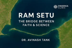
Amazing Facts about Ram Setu at Rameshwaram. Ram Setu connects Pamban Island (also known as Rameshwaram Island) in India to Mannar Island in Sri Lanka. It lies in the shallow waters of the Palk Strait and the Gulf of Mannar.
- Length: Approximately 48 km (30 miles)
- Width: Varies from 1.5 km to 4 km
- Depth: In most areas, the sea above the bridge is just 1–10 meters deep
The bridge is a chain of limestone shoals, sandbanks, and coral reefs — some of which are visible during low tide.
From above, the formation looks like a delicate, curved string joining two lands — so perfect that it’s hard to believe it’s only natural.
3. Is Ram Setu Man-Made? What Science Says
Scientists have long studied whether Ram Setu is a natural formation or man-made structure.
🔹 Geological Perspective
Most geologists believe that the bridge is a natural formation, created by a combination of:
- Tectonic movements
- Coral reef growth
- Sediment deposition
- Sea-level fluctuations over thousands of years
The shallow ridge may have formed naturally about 7,000 years ago, with sand and coral slowly building up into the chain of shoals visible today.
🔹 Archaeological and Radiocarbon Evidence
Some studies from the Geological Survey of India (GSI) and the National Institute of Oceanography (NIO) suggest that human activity could have modified natural formations to form a walkable causeway.
Carbon dating of the sand and coral samples has shown different ages — sand being much younger than the stones below — which has led some researchers to suggest that the stones might have been placed manually on an existing sandbank.
4. NASA’s Observation — What Is the Truth?
There has been much talk about NASA “confirming” that Ram Setu is man-made.
However, NASA has not made any religious or cultural confirmation about the bridge’s origin.
What NASA did do is capture high-resolution satellite images (from Terra and Aqua satellites) that clearly show the chain of shoals connecting India and Sri Lanka.
These images proved the physical existence of the structure — something already known — but they did not confirm who built it.
NASA scientists and other researchers simply state that Ram Setu is a visible natural formation of sandbanks and corals that resemble a bridge.
Still, the breathtaking imagery and perfect alignment of the shoals continue to intrigue people — keeping the legend of Lord Rama alive in every discussion.
5. Historical References to Ram Setu
Long before satellite technology, ancient and medieval maps had already marked the existence of this bridge.
- 9th-century Islamic texts referred to it as Set Bandhai.
- British surveys (1800s) called it Adam’s Bridge, inspired by the Islamic legend that Adam crossed it after being banished from Eden.
- In Tamil literature, it has been mentioned for centuries as Sethu Paalam — the “Bridge of Rama.”
Even Sri Lankan chronicles, like Mahavamsa, refer to the bridge and associate it with early human movements between the two islands.
Thus, both history and mythology intertwine beautifully around Ram Setu.
6. Dhanushkodi — The Ghost Town at the Edge of the Bridge
The Indian end of Ram Setu begins at Dhanushkodi, a narrow strip of land at the southeastern tip of Rameshwaram Island.
The name Dhanushkodi means “End of the Bow,” referring to the spot where Lord Rama is believed to have aimed his bow to mark the starting point of the bridge.
Dhanushkodi’s Tragic Story
Once a busy town with a railway line, church, and post office, Dhanushkodi was completely destroyed in a massive cyclone in December 1964.
More than 1,800 people died, and the town was declared “unfit for habitation” by the Government of India.
Today, Dhanushkodi is a hauntingly beautiful ghost town — with ruins standing as silent witnesses of nature’s power. Visitors can still see remnants of the railway station and church, and on clear days, even glimpse Sri Lanka’s Mannar Island across the sea.
Standing at Dhanushkodi, you can see where the Ram Setu begins — a spiritual experience that leaves most visitors awestruck.
7. Ram Setu and Environmental Significance
Amazing Facts about Ram Setu at Rameshwaram. The area around Ram Setu and the Gulf of Mannar is a marine biodiversity hotspot — home to over 3,600 species of flora and fauna, including corals, sea grasses, and endangered marine animals like dugongs.
Because of its fragile ecosystem, scientists have opposed dredging or altering Ram Setu, such as in the proposed Sethusamudram Shipping Canal Project, which aimed to create a navigable route between India’s east and west coasts.
Many environmentalists argue that destroying the shoals would damage marine life, affect coastal stability, and erase a natural-cultural heritage site.
Hence, Ram Setu is not just a religious monument, but also an ecological treasure worth preserving.
8. Can You See Ram Setu Today?
Yes, you can!
From the tip of Dhanushkodi, the chain of sandbanks is visible during low tide.
Tourists often travel to Arichal Munai, the last motorable point of India, to view where the land literally “ends” and the mysterious bridge begins.
During clear weather, aerial drone photography or satellite maps show the entire chain as a faint, curved line across the turquoise sea — an unforgettable sight.
9. Amazing Facts About Ram Setu
Here are some fascinating facts you may not know:
- Ram Setu is 48 km long, connecting India to Sri Lanka through a series of 103 small shoals.
- The water depth averages just 3 feet (1 meter) near the shoals, making it impossible for big ships to cross.
- NASA’s satellite images have made Ram Setu globally famous as a visible “bridge-like” structure from space.
- The stones found near Ram Setu are lighter than normal rocks and are believed to float in water due to trapped air pockets — sparking interest and devotion among pilgrims.
- Ram Setu’s region was once a continuous land connection — geological studies suggest India and Sri Lanka were joined around 7,000 years ago.
- It lies at the intersection of two large marine ecosystems: the Gulf of Mannar Biosphere Reserve and the Palk Bay coastal region.
- Ram Setu is also seen as the world’s oldest man-linked bridge, whether natural or human-assisted.
10. Ram Setu in Modern Times — Faith Meets Science
Even in the 21st century, Ram Setu continues to be a subject of debate, devotion, and discovery.
For the faithful, it’s an unshakable symbol of Lord Rama’s truth — proof that the divine epic of Ramayana was based on real events.
For scientists, it’s a natural formation shaped by centuries of ocean currents, but nonetheless a remarkable geological feature that aligns beautifully with the legend.
In recent years, several researchers, satellite experts, and independent explorers have supported further study of Ram Setu to understand both its geological age and cultural history.
Whatever your belief, one thing is certain — Ram Setu bridges more than two lands; it bridges faith and fact, history and hope.
11. Visiting Ram Setu and Dhanushkodi: A Pilgrim’s Guide
If you wish to experience this sacred site:
How to Reach Rameshwaram
- By Train: Rameshwaram Railway Station is connected to Chennai, Madurai, and Coimbatore.
- By Road: Accessible via the Pamban Bridge, which connects the island to mainland Tamil Nadu.
- By Air: Nearest airport is at Madurai (approx. 170 km).
Best Time to Visit
- October to March — Pleasant weather and calm seas make it ideal for sightseeing.
- Avoid monsoon months when tides are unpredictable.
Must-Visit Spots
- Ramanathaswamy Temple — One of India’s holiest Jyotirlinga shrines.
- Agni Theertham — Sacred sea where pilgrims take holy dips before temple darshan.
- Dhanushkodi Beach & Arichal Munai — Where the land ends and Ram Setu begins.
- Pamban Bridge — India’s first sea bridge and an engineering marvel.
- Kothandaramaswamy Temple — Ancient seaside temple believed to mark Vibhishana’s surrender to Rama.
12. The Message of Ram Setu
Ram Setu teaches us timeless lessons — of teamwork, faith, and human spirit.
It reminds us that with determination and divine guidance, even an ocean can be crossed.
Whether one views it through the eyes of science or spirituality, Ram Setu stands as a reminder of India’s rich cultural heritage and the enduring power of its sacred stories.
Conclusion
Amazing Facts about Ram Setu at Rameshwaram. Ram Setu is not just a bridge — it’s a living legend beneath the waves, uniting two nations and countless hearts.
It embodies faith, history, and natural beauty — all woven into a single breathtaking marvel at Rameshwaram.
From the divine story of Lord Rama to the modern satellite imagery by NASA, every layer of Ram Setu tells a story — a story that continues to inspire humanity to believe, explore, and preserve.